Roads, Peaks, and Stars: A Spontaneous Weekend Exploring the Blue Ridge Parkway
August 31, 2019 was the day after a new moon. The weather forecast called for clear skies, and I set my sights on the mountains of Western North Carolina to try my hand at photographing the Milky Way in the night sky.
Milky Way Photography, Mountain Peaks, and the Beauty of Late Summer
August 31, 2019 was the day after a new moon. The weather forecast called for clear skies, and I set my sights on the mountains of Western North Carolina to try my hand at photographing the Milky Way in the night sky.
This trip was spontaneous, like many of my road trip adventures, but I knew I wanted to head to the Blue Ridge Parkway* to find a viewpoint for my attempt at astrophotography. Over the years, I have been lucky enough to have lived close enough to the parkway that I could escape for a scenic drive through the picturesque Appalachian Mountains. The average elevation of the parkway is probably around 3500 feet (1060 meters) and seemingly around every curve, there is yet another stunning view. I’ve visited the parkway in all weather, during all seasons, and each time I visit, it feels like magic.

I am most familiar with the section that runs between Asheville and Blowing Rock, North Carolina so I began my search along this stretch. After some quick Google Map research and a consultation with my sun and astro apps, I had found a few locations with southwest orientation that would provide potential viewpoints of the rising Milky Way. Two locations were close to a campground that miraculously had availability despite it being a busy weekend at the tail end of the summer travel season. I booked a campsite and just like that, I had my first waypoints of the trip.
The trip began with the ascent along US-321, my entry point into the mountains from the central part of the state. After driving through the towns of Blowing Rock, then Boone, I diverted to the tiny town of Vilas Crucis to visit my next waypoint of the trip — the original Mast General Store. This historic general store is an iconic fixture in the region with multiple locations in The Carolinas, Tennessee and Virginia. This store has been operating in its original building with few changes since 1883. The exterior is dotted with relics of a bygone era: an old gas pump, a rusty plow, a metal Esso fuel station sign. The interior of the building still houses some original shelving, cabinetry, and display cases. During its heyday, there was a post office located onsite and the old metal lockboxes are still on display. The entire experience is akin to walking through a museum, it feels frozen in time.

The Mast General brand is known as a place to get anything outdoor related: light fishing tackle, camping supplies, pocket knives, outdoor clothing, cast iron for camp cooking. You can also pick up some cutesy metal signs for your man-cave or she-shed, t-shirts and ball caps with your favorite local college sports team’s logo, and even wooden rocking chairs for your front porch. But they may be best known for the old-timey general store ephemera — the barrels of bulk candy you can scoop into a bag, nostalgic toys and board games, local honey, jams and jellies, and sacks of stone-ground grits. It’s a great place to grab a souvenir. I wasn't in need of any new gear, so I opted for a few snacks and some photos of the historic building.
Back on the road, I arrived at my home base for the weekend—Grandfather Campground, named after the famous mountain it sits beneath. The campground was full with the last of the summer tourists fitting in a weekend trip, just like me. The only camp sites available were in the overflow lot, basically a field with no trees. I found my site and set up camp. I had not been camping in a long time (a very long time) and my old “Red Tent” was really showing its age with that characteristic “musty tent” smell. I was thankful for a clear, dry weekend ahead.

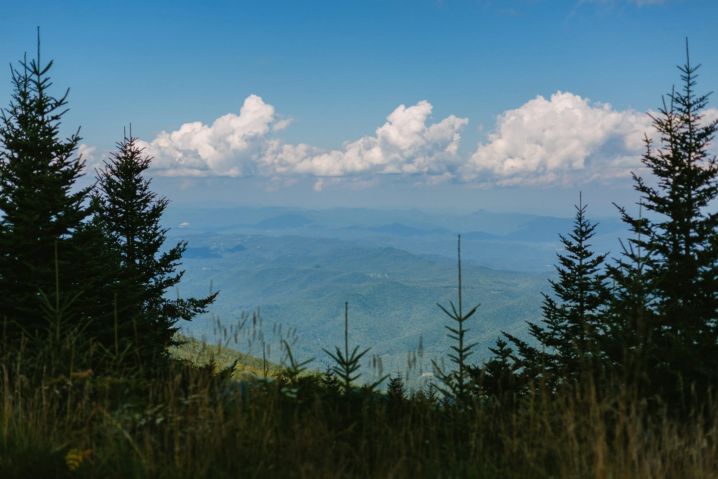
Evening was approaching and I wanted to scout my possible locations before I lost the light, so I headed out for the parkway. A short drive got me to my first vantage point — Beacon Heights Overlook. The parkway is dotted with scenic overlooks, some nothing more than a quick turn off, others with parking areas, access to trailheads, or even picnic grounds. Beacon Heights has one of the best views along the parkway, but it requires a quick hike from the parking lot. In less than a mile, you arrive at a patch of rock outcrops perched around 4300 feet (1300 meters) above the Piedmont region below. The views down the Blue Ridge escarpment are expansive, it truly is one of the best views from the parkway.

I caught the sunset here, but decided the view didn’t offer enough of the southwestern sky that I would need to view the Milky Way later that night. So I backtracked up the parkway to my second possible site — Rough Ridge Lookout. This spot also required a quick hike to reach the viewing platform and after a steep but brief 15 minute ascent, I was balancing on the jutting rocks that topped the small peak. Outstretched before me was the silhouetted mountain tops of the lower Blue Ridge Mountains. The mountain tops rolled on for miles in the distance and the view was stunning. I had found my spot.

The Milky Way wouldn’t rise for another couple hours, so I headed back to camp for a quick dinner and some camera prep. When I returned, the trailhead was empty of signs of any other travelers. I was the only person crazy enough to hike this trail at night. I packed my gear, donned my headlamp, and calmed my nerves slightly — it was pitch black on this moonless night. But having just hiked the same trail a few hours ago, I was confident about the route and I knew I would be alone on the trail. Once at the top and with my view determined, I began to settle in. It was starkly quiet at the top of the mountain, no noise from the parkway below, only the soft sounds of the night forest. It was calming and I felt quite safe.
Astrophotography is not my specialty, so I played with my camera settings until I felt I had a recipe that would get me the results I was looking for— a high ISO, a wide open lens, and a slow shutter. The viewfinder showed me viable images that I knew I could work with in the edit. I stuck around for about an hour, perched high on the ridge, alone and surrounded by darkness. Some rustling in the forest behind me ultimately convinced me I had captured enough images and I hiked back down to my car. I drove back down the parkway and returned to the campground, driving slowly and using only my running lights to avoid disturbing the other campers too much. I like to think I practiced proper campground etiquette.

The next morning, I slept in somewhat after my late night hiking escapade, but was excited to get in my serious hike of the trip. Grandfather Mountain is one of the most familiar peaks along the Blue Ridge Mountains. It’s known for its stunning views, swinging bridge hikes, and maybe most famously, the “Grandfather” profile in the rockface. I chose to hike Calloway Peak via the Profile Trail so I could catch a glimpse of the famous face. The old man did not disappoint. The trail is fun and strenuous with the ascent to the peak being almost 2000 feet (600 meters). Along the way there are lots of rock scrabbles and ladders near the top, but the effort is worth it for the views.

That evening, I returned to the parkway to attempt a timelapse of the sunset from yet another viewpoint — Flat Rock Loop. Another short hike brought me to a rocky outcrop, this time with views facing due west, excellent for sunset. The sky that evening had some passing clouds that shrouded the best of the colors, but they did part way long enough for me to catch a glimpse of the silver sliver of the waxing crescent moon.

The following morning, I packed up camp. It was my final day on the parkway and I planned to put in some miles. My first waypoint of the day was Linville Falls, a place that had been on my bucket list for a long time. Linville Falls is one of the most iconic sights along the parkway. The cascading waterfall drops about 90 feet over three different sets of falls. The final set funnels the water from a narrow gorge resulting in a spectacular display of cascading water into the pool below. The hike down into the gorge was brief but worth it for views right along the waterline of the pool.

Leaving the falls, I settled in for a couple dozen winding miles along the parkway and soaked in the stunning views. I stopped at overlooks when one caught my attention, taking more photos of the long range views, which never get old. To my surprise, I came upon an orchard just off the parkway. The Orchard at Altapass cascades down from the ridge of the parkway with neat rows of apple trees lining the slope. I pulled off the parkway and made my way into the orchard. It was still considered early during apple season, but a few early season varieties were available and I purchased a selection as road snacks.

After a couple more overlook stops, I arrived at my next waypoint of the trip — Mt. Mitchell. The peak at Mt. Mitchell towers an impressive 6684 feet (2037 meters) above sea level, which is the highest peak east of The Mississippi River in the United States. The observation deck offers 360° views of the surrounding mountains, a truly awesome experience when the skies are clear. Lucky for me, I was able to clearly see the long range views that day.


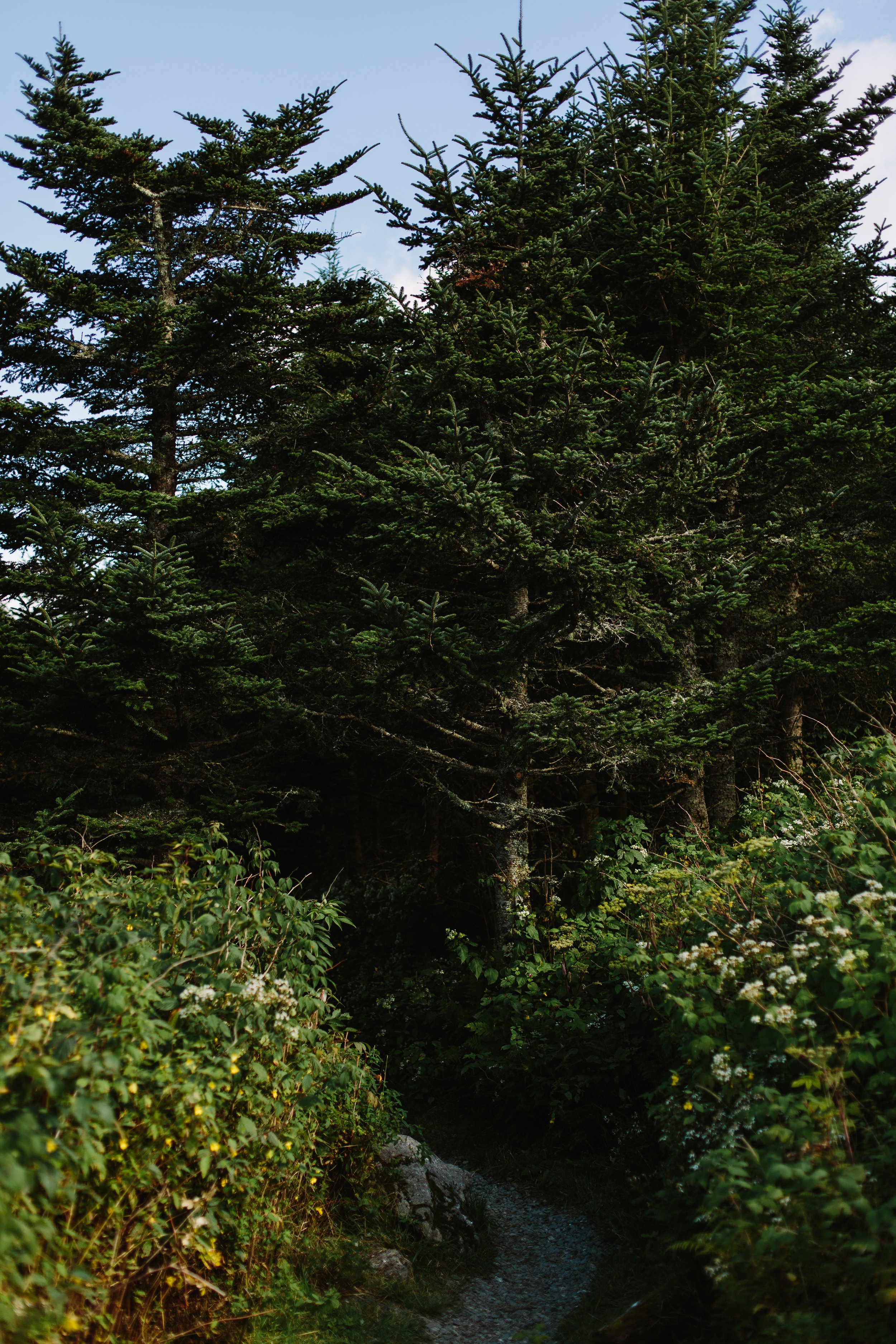
The elevation at the highest levels of the mountain enables a climate that supports a Fraser fir forest, rarity in these latitudes. The trees are coated in mosses, the ground covered in ferns, and the air thick with cool moisture. It feels more like the lush forests of Maine or the Pacific Northwest which is a stark contrast to the heat just a few hundred feet below the peak. The Balsam Nature Trail is a short, easy hike that submerges hikers in this enchanted forest world.


I continued along the parkway to my final waypoint, and one of my favorite locations, — Craggy Gardens. This is one of the most popular spots along the parkway for many reasons. Not only does it have amazing views in multiple directions and from multiple points, but it is also surrounded by acres of dense rhododendrons. These shrubs hug the slopes bordering the parkway and in early summer, the pink and purple blooms are captivating. On this summer day, the flowers long since bloomed, so I simply soaked in the views under the clear blue sky.

Departing my final stop on the parkway that day, I made my way down from the mountains on Route 80. The stretch of road near the intersection with The Blue Ridge Parkway is known as “The Devil’s Whip” because of its quick elevation exchange and multiple curves and switch backs. It’s a fun stretch of road to drive, but not to be a passenger. I always drive it carefully, since it’s a popular route for motorcyclists.
As my summer sojourn came to a close and I merged on the interstate that would take me home, I looked into the rearview mirror and saw a view I will never forget. I actually had to pull over for this one. Exit 94 on I-40 has one of the most incredible views from any highway I’ve seen in the south east. Looking west, the highway ascends slightly and all of the sudden, the peaks of the Blue Ridge Mountains emerge into view, growing ever taller until you pass the exit. It's a point on the highway that always signifies something special to me — I’m either on my way to the mountains or I just came from them, and either way, I know life is good.

*Many of the locations mentioned in this post were disastrously affected by Hurricane Helene in September, 2024. Please do your research when planning a visit to the region. At the time of this publication, many places have reopened for business and are gladly welcoming travelers. However, some businesses and locations are still recovering from the extensive damage. There are still many road closings along The Blue Ridge Parkway. You can visit the Official Blue Ridge Parkway Website for road closure updates. Another great resource is VisitNC.com, where you can find travel updates for the entire state.
Want to see everything in one place?
I’ve mapped out all the must-visit spots, trails, and hidden gems from this guide in an interactive Google Map. Check it out here and start planning your own adventure!

Blue Ridge Parkway Guide
Best Hikes & Overlooks (MM 306-365)
Thanks for reading along. If you’re interested in travel that’s a little less polished, a little less planned, and a lot more focused on the feeling of being in a place, subscribe to Waypoints. Paid subscribers receive an exclusive discount on all prints and products in the shop.
Let's wander a little slower, and see what we find.
Lindsey A. Miller

An Ephemeral Souvenir
We’re here, Lisbon—Lisboa, Portugal. This city is impossibly gorgeous, in a familiar yet uniquely original way. I’m smitten immediately.
A situation ripe for accidental discovery
We’re here, Lisbon—Lisboa, Portugal. This city is impossibly gorgeous, in a familiar yet uniquely original way. I’m smitten immediately. Colorful, stepped buildings line the hills, cascading into the sea. The streets flow from the water, carving erratic paths into the hillsides. Buildings grow organically on the grade of the hills. I beg you to find a right angle here.
We are staying in the Alfama, the historic Moorish neighborhood of Lisbon. We enter the ancient section and our driver slows to navigate the winding streets. She gets us to a place where the car can no longer pass through, we must traverse the rest of the way on foot. We are directed to navigate through a tiny plaza and make our way up an almost hidden staircase. We walk past open doors and windows, cartas slots for mail, plants in pots balanced on stone steps. Inward we go, deeper, it is oddly quiet here.

Midway up the stairs, we arrive at our accommodations, a third story apartment. The ascent seems impossible, three stories of wooden stairs traversed in about 12 feet. The angle of this staircase was a few degrees away from a ladder. With our bags strapped to our backs, we hike the stairs to our lofty tower. I feel like I’m traveling back in time. How will we get back down?
After dropping our bags, we head out for a walk to explore the neighborhood. Without a destination in mind we make our way through the streets. Hungry from travel, our bellies discover a restaurant, two tiny tables with tiny stools are precariously perched out front on the slanted sidewalk. We grab a seat on the hillside.


Out comes the server, a thin man with glasses who immediately begins to enthusiastically speak to us in English. We ask for his recommendations, both for food and wine and he brings us exactly what we are hoping for—beautiful tinned fish, freshly plated, dripping with glistening olive oil, moist, fluffy bread and of course, chilled vinho verde. It’s Petisco Hour.
Vinho Verde, that beautiful, young, crisp Portuguese original, is low alcohol. Thirsty from travel, we drink without reservation. Two tins of fish and a bottle later, we take our soft wine buzz and continue our meanderings.


Deep within the labyrinth of Alfama, pastel walls with their soft hues and smooth textures rise up from the weathered cobblestones of the Escherian alleyways. Laundry gently flows in the wind, strung on clotheslines outside the windows in the stories above. A gray camouflage of erratically patterned mosaic cobblestones is accentuated by the lush green of plants in terracotta pots. It is lovely, organized chaos.
We enter this medieval world at the base of a hill, wandering through the turns, our route obscured by the high walls of the ancient Alfama buildings. At each new interchange, we always chose “up.” Our destination—a castle, perched up high. Submerged in this hushed world, soft music billows from an open window, narrating the moment. It feels like a movie scene.


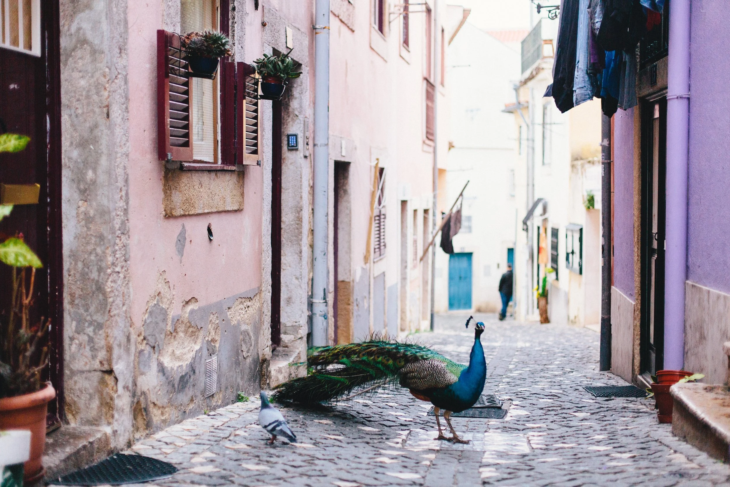
Looking up a curving alleyway, something exotic yet familiar walks slowly near the ground, the colors giving a clue to its taxonomy. Suddenly, a distinctive shrill pierces the silence—the classic tell of an iconic bird. His call is echoed by a hidden, potential mate, a peahen somewhere deeper in the Alfama. Although he is walking without his tail presented, his classic colors are undeniable. We are looking at a beautiful male peacock. Is this real or is this a fleeting dream?
Lulled by this romantic moment, we couldn’t help but play the role of token tourists. With cameras in outstretched hands and video rolling, we follow him, we flirt with him, we beckon him to display his beautiful feathered fan. But he wasn’t in a dapper mood, nor did he squander his exhibition on us humans.

A car slowly makes its way into the alleyway and startles the pigeons. Just like that, the bubble pops and the dream state is over. Dusk settles in and the streetlights begin to turn on. We make our way back down the hill, away from the walls of the castle, away from the peacock calls, away from the trance. Charmed with this uniquely Alfama-moment, we decide to make it a memory, an ephemeral souvenir.
I’m always amazed by the serendipity that accompanies travel. Heightened senses, new experiences, and abated inhibitions all combine to make the situation ripe for accidental discovery. A moment before, a moment after, one different turn, and the moment, this moment, would not exist. This is why I travel. I live for collecting these moments, these memories, these ephemeral souvenirs and adding them to the treasury that is the sum of my experiences.
Thanks for reading along. If you’re interested in travel that’s a little less polished, a little less planned, and a lot more focused on the feeling of being in a place, subscribe to Waypoints. Paid subscribers receive an exclusive discount on all prints and products in the shop.
Let's wander a little slower, and see what we find.
Lindsey A. Miller

Anatomy of a Roadtrip
Many of my photographs are the result of my travels. What photographer doesn’t love travel or began their photography obsession with travel photography? I certainly fit the trope of a young American kid backpacking through Europe with a film camera in tow. I fell in love with architecture and markets, street vendors and gardens, esplanades and town squares. My love for documentary style photography is a throughline in my work.
A winter roadtrip down the Delmarva Peninsula
Many of my photographs are the result of my travels. What photographer doesn’t love travel or began their photography obsession with travel photography? I certainly fit the trope of a young American kid backpacking through Europe with a film camera in tow. I fell in love with architecture and markets, street vendors and gardens, esplanades and town squares. My love for documentary style photography is a throughline in my work.
Blackwater National Wildlife Refuge | 2021
International travel is a passion of mine, but hopping a flight and crossing the pond or other massive body of water to collect stamps in my passport is not something I have the privilege of doing frequently. So back here in the states, I feed my insatiable need for exploration and discovery by taking road trips.
Having lived in the coastal Southeast for more than 30 years, I’ve become well acquainted with and quite fond of the barrier islands that guard our eastern shores. These dynamic land masses are in constant flux making them a fascinating study of geology and climatology. They are also archaeologically and historically significant, playing important roles in the history of indigenous people populations as well the early American settlers.
Nowadays, many of these barrier islands have been developed into vacation spots with high end real estate. However there are a significant number of undeveloped and protected islands that still harbor the natural beauty of these sandy sentinels.
A few of the protected islands I’ve had the privilege of visiting and exploring include: Masonboro Island off the coast of North Carolina near Wilmington; Hunting Island in South Carolina south of Charleston; and all the barrier islands of The Outer Banks in North Carolina, many of which have protected land.
There are hundreds of barrier islands on the Atlantic and Gulf coastlines here in the states, many of which are undeveloped and only accessible by boat. I’ve had the idea for years to create a photo project to document all the major barrier islands up the east coast. It’s definitely a long-term bucket list project.
Blackwater National Wildlife Refuge | 2021
How I Got to Delmarva
In January 2021, I was leaving New England and driving back to South Carolina and decided to make a road trip out of the commute. Having recently visited the Outer Banks of North Carolina, I wanted to expand my barrier island exploration further north up the east coast and visit coastal Maryland and the Delmarva Peninsula.
I didn’t know anything about the Delmarva, other than at the southern point was the Chesapeake Bay Bridge Tunnel. And as an avid road tripper, driving through the tunnel was high on my list. So I made the tunnel a waypoint on the road trip and began to research what I could find in between.
I immediately discovered the barrier islands of Chincoteague and Assateague and the feral horse population that reside in the marshes and forests. I decided to make the Chincoteague National Wildlife Refuge another waypoint on the trip. Overnighting on the peninsula was necessary and I found a tiny cabin on Airbnb making it another waypoint. My route was mapped out, all that was left was to explore along the way.
Blackwater National Wildlife Refuge | 2021
The Beauty of Unseen Places
The Delmarva is a quiet, sparsely populated flat stretch of land, full of farmland and forests with The Atlantic coastline to the east, and Chesapeake Bay shoreline to the west. The bay was a formidable barrier, a vast yet gentle wash that further isolated the region. I had never seen the bay before and its calmness was a stark contrast to the constant churning of the ocean. Visiting in January and during the tail end of the COVID lockdowns cast an even deeper level of quietude on the area. There wasn’t much to explore other than to witness the bucolic landscapes that stretched on for miles.
In Cambridge, MD, I saw the familiar calling card of hand painted signage on a corrugated metal building that broadcasted, “ANTIQUES.” The building was adorned with the token wagon wheels and rusty antique farm tools that are familiar ephemera for these picker paradises and I knew it would be a good respite after the hours of driving. The front windows housed a rainbow display of colored glass pieces that felt like a portal beckoning me into a magical world. Once in the entryway, I was welcomed with a circle of glass display cases full of antique ephemera – jewelry, trinkets, pocket knives, and other tiny collectibles.
Dark Horse Antiques, Cambridge, MD | 2021
Sitting behind the glass barrier was the old man who ran the Dark Horse Antiques shop - Richard a.k.a. Rick and his wife Barbara. He told me they were from Minnesota originally and they came from a family of farmers. Without my inquiry, he told me a story about a massive snowstorm in the 1970s. The Chesapeake Bay froze over and a man drove a VW Beetle across the ice from down in one of the Waterman towns up to Cambridge because he didn’t want to cross all the bridges. (He called it Waterman Jones, I was unclear if the name was in reference to the town or the man.)
In the shop, my treasure hunt rewarded me with two books to add to my used book collection. The first, “Fisherman’s Luck” by Henry Van Dyke, a stunning antique circa 1899. I fell in love instantly with the pale green fabric and gorgeous gold embossed fish on the cover. Inside was a pasted card outlining “The Saturday Book Club,” a ladies book club which included the handwritten names, addresses, and dates when its members checked out this copy. After some quick sleuthing on a map, I pieced together the addresses and found the club was located in Brooklyn, NY. I felt like I stepped back in time when I opened its cover. I daydreamed about the ladies from the early 20th century and why they might have belonged to a book club and how they discussed the stories inside this copy.
Antique Books
The second book I found was an 1959 publication of a collection of poetry from E. E. Cummings. It was a collectors item, which was my main reason for bringing it home with me. But I also secretly want to exercise my brain by reading some of the most beautiful and challenging poetry I’ve ever encountered. I’ve always aspired to be the type of person who reads poetry for fun, but admittedly, I still struggle with comprehension. I tend to take it too literally. I haven’t finished the book.
After a quiet overnight in the tiny cabin, I made my way east towards the barrier islands and their mythic horses. Passing through the rural towns of the central peninsula, I was shocked to see a collection of enormous satellites at the marsh edge just before the islands. I had come upon NASA's Wallops Flight Facility, an unexpected technological presence along the eastern shore. I was unaware there were any NASA launch facilities outside of Florida and Texas. Surprise encounters like this are why I love road trips so much
Bucket List Barrier Islands
Upon entering Chincoteague Island, the coastal village had distinct echos of New England coastal towns with a small main street area and a few clapboard cottages. The day I visited, it was chilly and overcast with intermittent light rain, adding a slight layer of forlornness. I took the short drive from Chincoteague Island to Assateague Island, and entered the Chincoteague National Wildlife Refuge, the protected area where the wild horses roamed.
Wild Pony in Chincoteague National Wildlife Refuge | 2021
My first horse sighting was simply joyous! From my car, I could see a small herd of the wild horses grazing in the distant marsh. The tidal waters must have been low enough to enable them to wander out into the grass. The horses were stout, and looked more like ponies (they are referred to as both, although technically, they are horses.) Most had brown and white patterned hair, which I now know is a pinto pattern.
The ponies seemed out of place here. Their presence in the marshy, swampy surroundings evoked a layer of fantasy and I couldn’t help but think of one of my favorite childhood movie characters – Artax, the loyal horse companion of the warrior Atreyu in The Neverending Story. All I could see was Artax and Atreyu wandering through the Swamp of Sadness, and on this dreary, cold day, I felt the loss of that fictional horse.
Great Egret, Chincoteague National Wildlife Refuge | 2021
The Wildlife Refuge was beautiful and despite the cold, wet weather, I went for a nature walk along the trails. I saw many different species of waterfowl floating in the tidal creeks and wading in the marshes. More ponies were grazing in a separate part of the island, distancing themselves from the few tourists who braved the weather. The island was quite peaceful on this cold winter day.
I departed the reserve and made my way to the southern terminus of the peninsula, my exit point, The Chesapeake Bay Bridge Tunnel. This modern marvel of engineering did prove to be exciting, and a little bit unnerving. The almost 18-mile long expanse of bridges and two tunnels spans the vast mouth of the great bay. Traveling along the narrow stretches of concrete felt isolating and diving below the surface in the tunnels was shockingly claustrophobic. I was relieved to reach the Virginia shoreline.
Take the Trip – You Won’t Regret It
My trip down The Delmarva was a memorable one, full of welcomed quietude, bucolic landscapes, and unexpected discoveries. The unique circumstances of a slow winter shortly after the COVID lockdowns only added to the distinction of the experience – I knew I’d never get to experience the peninsula in the same way again.
Fishing Wharf near Cambridge, MD | 2021
I’ve come to love solo road trips, I have dozens under my belt now spanning Upstate New York, The Panhandle of Florida, The Appalachians of Western North Carolina and Georgia, multiple barrier islands along the Carolina coasts, and everywhere in between. I hit the road as often as I can, with only a waypoint or two—the rest unfolds naturally. Not only do these trips lead to discoveries of parts unknown, but they have enabled me to experience parts of our country mostly unknown to outsiders. I’ve been able to see deeper into these places and broadened my understanding of the unique, regional cultures. This is a vast and diverse country, and I have so much left to explore.
My love of solo travel and road trips are deeply ingrained in who I am and I truly love sharing my experiences with others. My goal is to shed light on places that might otherwise go unnoticed by most travelers. My hope is to inspire others to take a journey of their own and uncover their own wonderful discoveries.
Thanks for reading along. If you’re interested in travel that’s a little less polished, a little less planned, and a lot more focused on the feeling of being in a place, subscribe to Waypoints. Paid subscribers receive an exclusive discount on all prints and products in the shop.
Let's wander a little slower, and see what we find.
Lindsey A. Miller

Welcome to Waypoints
I wanted to take a moment to share something exciting with you—introducing Waypoints, a space dedicated to slow, intentional travel and storytelling.
Travel, for me, has never been about checking off bucket lists or chasing the next viral photo. It’s about the in-between moments—the quiet detours, the hidden corners, and the unexpected beauty that unfolds when we take our time. Waypoints is where I’ll explore that, through photography, video, and written reflections.
A New Chapter
I wanted to take a moment to share something exciting with you—introducing Waypoints, a space dedicated to slow, intentional travel and storytelling.
Travel, for me, has never been about checking off bucket lists or chasing the next viral photo. It’s about the in-between moments—the quiet detours, the hidden corners, and the unexpected beauty that unfolds when we take our time. Waypoints is where I’ll explore that, through photography, video, and written reflections.
While my love for capturing visual stories remains the same, you can now expect more travel narratives, road trip discoveries, and thoughtful observations about the places we encounter along the way. My focus will be on the Southeast United States and beyond—wherever the road takes me.

Here you’ll find photo essays woven into a broader exploration of slow travel—the kind that doesn’t rush, that notices the details, and that values experience over checklists.
I’m so grateful you’re here, and I hope you’ll continue this journey with me. If you love what you read, I’d be thrilled if you would subscribe to Waypoints. By subscribing, you’ll get full access to all posts delivered straight to your email inbox. Paid subscribers receive an exclusive discount on all prints and products in the shop.
Let’s wander a little slower and see what we find.
More soon,
Lindsey